Related Publications
Severe impacts on water resources projected for the Mediterranean Basin
WIREs Water 12 (2): e70012, 2025
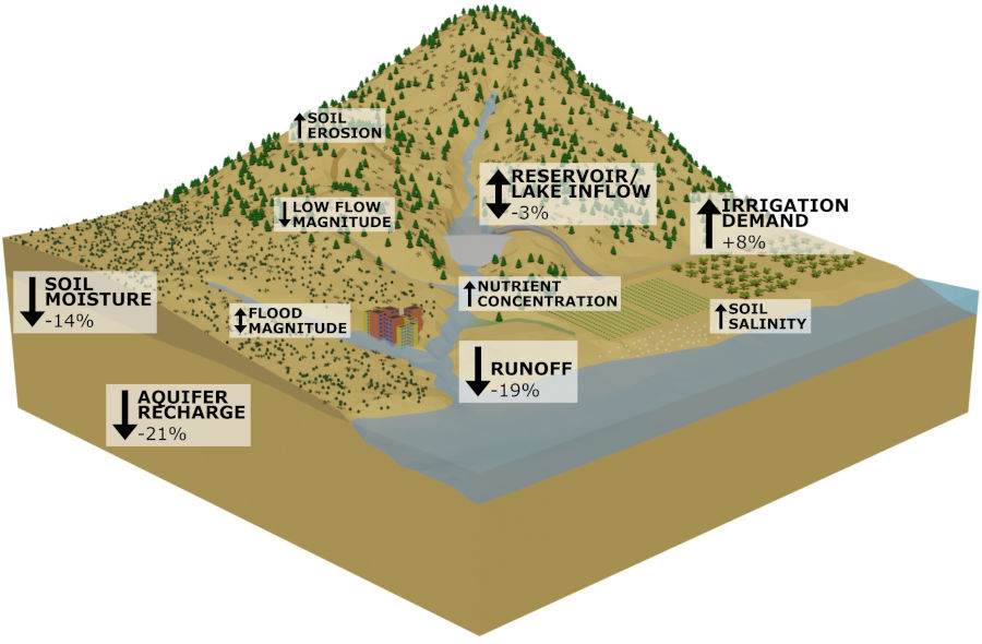
Water resources are becoming increasingly scarce in the Mediterranean Basin due to climate change. Through a systematic review of 262 catchment-based Mediterranean studies, we provide improved and detailed indications that runoff is projected to decrease by 19%, with increasing severity towards the end of the century and with increasing emission scenarios (up to −39%). We also show negative consequences for other water resources (soil moisture, aquifer recharge, irrigation demand), hydrological extremes (low flows), and water and soil quality (nutrient concentration, soil salinity, soil erosion), with negative impacts on rainfed and irrigated agriculture in the Mediterranean Basin. To protect water security, climate change adaptation aiming at more efficient water use and water retention in soils will be needed. While these adaptation measures have the potential to reverse the impacts of climate change, they may reduce downstream water availability and may be insufficient under extreme climate conditions.
Using quantile mapping and random forest for bias-correction of high-resolution reanalysis precipitation data and CMIP6 climate projections over Iran
International Journal of Climatology 44 (12): 4495-4514, 2024
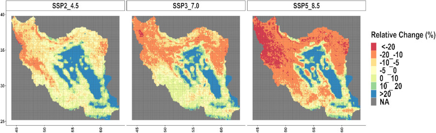
Climate change is expected to cause important changes in precipitation patterns in Iran until the end of 21st century. This study aims at evaluating projections of climate change over Iran by using five climate model outputs (including ACCESS-ESM1-5, BCC-CSM2-MR, CanESM5, CMCC-ESM2 and MRI-ESM2-0) of the Coupled Model Intercomparison Project phase 6 (CMIP6), and performing bias-correction using a novel combination of quantile mapping (QM) and random forest (RF) between the years 2015 and 2100 under three shared socioeconomics pathways (SSP2-4.5, SSP3-7.0 and SSP5-8.5). First, bias-correction was performed on ERA5-Land reanalysis data as reference period (1990–2020) using the QM method, then the corrected ERA5-Land reanalysis data was considered as measured data. Based on the corrected ERA5-Land reanalysis data (1990–2020) and historical simulations (1990–2014), the future projections (2015–2100) were also bias-corrected utilizing the QM method. Next, the accuracy of the QM method was validated by comparing the corrected ERA5-Land reanalysis data with model outputs for overlapping years between 2015 and 2020. This comparison revealed persistent biases; hence, a combination of QM-RF method was applied to rectify future climate projections until the end of the 21st century. Based on the QM result, CMCC-ESM2 revealed the highest RMSE in both SSP2-4.5 and SSP3-7.0 amounting to 331.74 and 201.84 mm·year−1, respectively. Particularly, the exclusive use of the QM method displayed substantial errors in projecting annual precipitation based on SSP5-8.5, notably in the case of ACCESS-ESM1-5 (RMSE = 431.39 mm·year−1), while the RMSE reduced after using QM-RF method (197.75 mm·year−1). Obviously, a significant enhancement in results was observed upon implementing the QM-RF combination method in CMCC-ESM2 under both SSP2-4.5 (RMSE = 139.30 mm·year−1) and SSP3-7.0 (RMSE = 151.43 mm·year−1) showcasing approximately reduction in RMSE values by 192.43 and 50.41 mm·year−1, respectively. Although each bias-corrected model output was evaluated individually, multi-model ensemble (MME) was also created to project the annual future precipitation pattern in Iran. By considering that combination of QM-RF method revealed the lower errors in correcting model outputs, we used the QM-RF technique to create the MME. Based on SSP2-4.5, the MME climate projections highlight imminent precipitation reductions (>10%) across large regions of Iran, conversely projecting increases ranging from 10% to over 20% in southern areas under SSP3-7.0. Moreover, MME projected dramatic declines under SSP5-8.5, especially impacting central, eastern, and northwest Iran. Notably, the most pronounced possibly decline patterns are projected for arid regions (central plateau) and eastern areas under SSP2-4.5, SSP3-7.0 and SSP5-8.5.
The IAHS Science for Solutions decade, with Hydrology Engaging Local People IN a Global world (HELPING)
Hydrological Sciences Journal 69 (11): 1417-1435, 2024
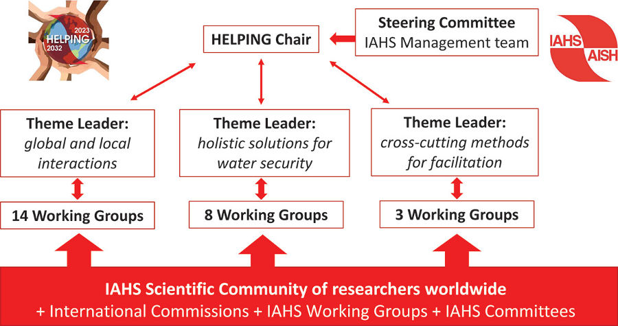
The new scientific decade (2023-2032) of the International Association of Hydrological Sciences (IAHS) aims at searching for sustainable solutions to undesired water conditions - may it be too little, too much or too polluted. Many of the current issues originate from global change, while solutions to problems must embrace local understanding and context. The decade will explore the current water crises by searching for actionable knowledge within three themes: global and local interactions, sustainable solutions and innovative cross-cutting methods. We capitalise on previous IAHS Scientific Decades shaping a trilogy; from Hydrological Predictions (PUB) to Change and Interdisciplinarity (Panta Rhei) to Solutions (HELPING). The vision is to solve fundamental water-related environmental and societal problems by engaging with other disciplines and local stakeholders. The decade endorses mutual learning and co-creation to progress towards UN sustainable development goals. Hence, HELPING is a vehicle for putting science in action, driven by scientists working on local hydrology in coordination with local, regional, and global processes.
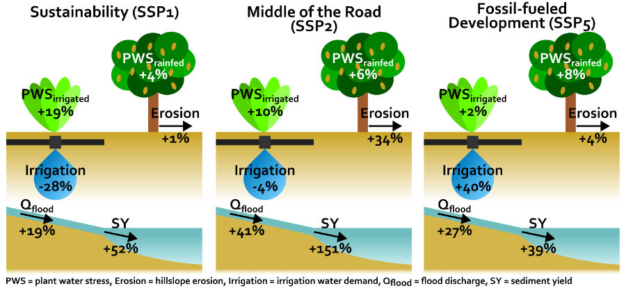
How future changes in irrigation water supply and demand affect water security in a Mediterranean catchment
Agricultural Water Management 297: 108818, 2024
It is likely that climate change will increase irrigation water demand and, consequently, reduces water security in the Mediterranean Basin if current irrigation supply and demand conditions are maintained. Climate change adaptation can be achieved by (1) decreasing irrigation water demand through more efficient irrigation techniques, (2) increasing irrigation water supply by adopting new technological advances, (3) converting to rainfed agriculture, and (4) implementation of Nature-based Solutions for water retention. The aim of this study was to assess the effectiveness of different combinations of these adaptation options on water security through analysis of contrasting scenarios of socio-economic development. We defined plausible scenarios of climate change, land use change and adaptation measures for an intensively irrigated catchment in south-eastern Spain under three Shared Socioeconomic Pathways (SSP), representing different storylines of socio-economic development. We considered three SSP scenarios, including the Sustainability pathway (SSP1), the Middle of the Road pathway (SSP2) and the Fossil-fueled Development pathway (SSP5). Future land use distributions were obtained with the iClue land use change model by accounting for differences in irrigation water demand and supply, resulting in a decrease (SSP1), a constant (SSP2) and an increase (SSP5) in irrigated agriculture. The impact of each scenario on a series of water security indicators was quantified using the SPHY-MMF hydrology-soil erosion model. The SSP2 scenario, which considers very limited climate change adaptation, projects the most severe impacts on water security, including an increase in plant water stress, flood discharge, hillslope erosion and sediment yield. Under SSP1, which accounts for most climate change adaptation strategies, irrigation water demand is significantly reduced due to a shift from irrigated to rainfed agriculture and the implementation of reduced deficit irrigation, while Nature-based Solutions reduce the impact on other water security indicators. Under SSP5, a conversion from rainfed to irrigated agriculture causes a significant increase in irrigation water demand, which is met by increasing irrigation water supply from desalination. SSP5 shows intermediate impacts on other water security indicators, which is explained by a strong decrease in annual precipitation. This study helps exploring how different future socio-economic pathways affect water security and thereby supports evidence-based policy development.
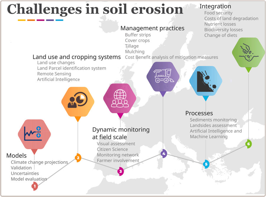
How the EU Soil Observatory contributes to a stronger soil erosion community
Environmental Research 248: 118319, 2024
New policy developments have emerged in relation to soil conservation after 2020. The Common Agricultural Policy (CAP) 2023–2027, the proposal for a Soil Monitoring Law and the mission ‘A Soil Deal for Europe’ have shaped a new policy framework at EU level, which requires updated assessments on soil erosion and land degradation. The EU Soil Observatory (EUSO) successfully organised a scientific workshop on ‘Soil erosion for the EU’ in June 2022. The event has seen the participation of more than 330 people from 63 countries, addressing important topics such as (i) management practices, (ii) large scale modelling, (iii) the importance of sediments in nutrient cycle, (vi) the role of landslides and (v) laying the foundations for early career scientists. As a follow up, among the 120 abstracts submitted in the workshop, we received fifteen manuscripts, out of which nine were selected for publication in the present special issue. In this editorial, we summarize the major challenges that the soil erosion research community faces in relation to supporting the increasing role of soils in the EU Green Deal.
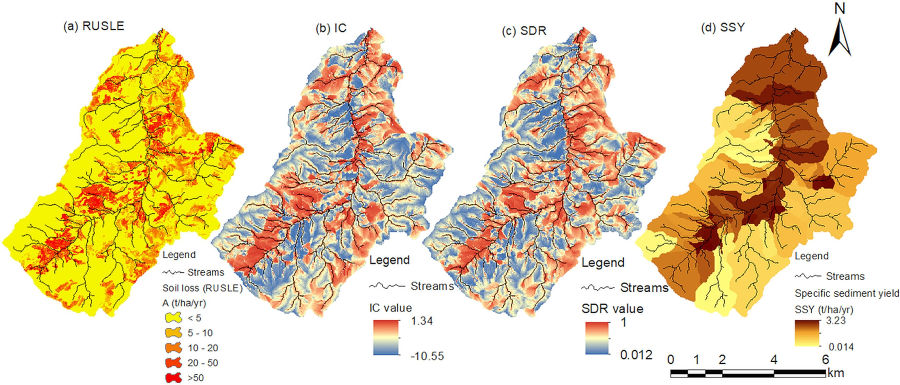
The potential and challenges of the ‘RUSLE-IC-SDR’ approach to identify sediment dynamics in a Mediterranean catchment
CATENA 233: 107480, 2023
Soil erosion is a natural process that can be accelerated by natural and anthropogenic disturbances and lead to land degradation and geomorphological changes. Analyzing soil erosion and catchment sediment dynamics is a complex process. In such cases, simplified methods can be applied to analyze soil erosion and sediment connectivity variations and to understand sediment flux in a river basin to inform watershed management. In this study, we tested the combined method of the Revised Universal Soil Loss Equation (RUSLE), the Index of Connectivity (IC), and the Sediment Delivery Ratio (SDR) to estimate sediment yield (SY) and investigate the spatiotemporal variation of soil erosion rates and sediment connectivity in the Mediterranean Rogativa catchment (∼53 km2), Southeast Spain. In this ‘RUSLE-IC-SDR’ approach, the sediment delivery ratio was estimated from the spatially distributed index of connectivity, calculated using SedInConnect and accounting for the trapping efficiency of 58 check dams in the channels, while assuming 100 % sediment delivery in other parts of the channels. The sediment delivery ratio was calibrated, and sediment yield was verified for the year 2001 using observed sediment yield (in 2003) behind the non-silted check dams. Predicted soil erosion, connectivity (IC, SDR, and SY), and soil erosion-connectivity maps were quantified and compared over time and space, revealing the impacts of rainfall, land use, and check dams. These maps show higher values for areas closer to the channels than on the hillslopes, and higher values on croplands than other land use types, as well as a decrease over time due to land use change and the construction of check dams. The relatively simple ‘RUSLE-IC-SDR’ approach was found to be effective in identifying the sources and hotspots on the hillslopes of a complex Mediterranean catchment. Future studies should consider the channel erosion processes as the RUSLE-IC-SDR does not take these into account.