I’m a postdoctoral researcher with a Juan de la Cierva fellowship in the Soil and Water Conservation Research Group in CEBAS-CSIC (Murcia, Spain). Currently, I focus on the impact of climate change and landuse change on hydrology and soil erosion in Mediterranean environments. In collaboration with FutureWater I have developed a coupled hydrology-soil erosion model (SPHY-MMF), which I have applied in the Segura River catchment. Please visit the pages related to my research output (publications, presentations and projects) and to my outreach activities (blog and videos).
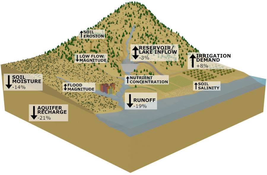
Recently, I published a systematic review in Earth-Science Reviews along with my colleague Joris de Vente, in which we studied the impact of climate change on soil erosion, with an additional focus on conservation measures and land use change. This is the first systematic review that I have published, but it already gave me some interesting insights. In this blog post I want to share those insights, which hopefully can help you in your next systematic review. First, I will give a short overview…
CATENA 233: 107480, 2023
Soil erosion is a natural process that can be accelerated by natural and anthropogenic disturbances and lead to land degradation and geomorphological changes. Analyzing soil erosion and catchment sediment dynamics is a complex process. In such cases, simplified methods can be applied to analyze soil erosion and sediment connectivity variations and to understand sediment flux in a river basin to inform watershed management. In this study, we tested the combined method of the Revised Universal Soil Loss Equation (RUSLE), the Index of Connectivity (IC), and the Sediment Delivery Ratio (SDR) to estimate sediment yield (SY) and investigate the spatiotemporal variation of soil erosion rates and sediment connectivity in the Mediterranean Rogativa catchment (∼53 km2), Southeast Spain. In this ‘RUSLE-IC-SDR’ approach, the sediment delivery ratio was estimated from the spatially distributed index of connectivity, calculated using SedInConnect and accounting for the trapping efficiency of 58 check dams in the channels, while assuming 100 % sediment delivery in other parts of the channels. The sediment delivery ratio was calibrated, and sediment yield was verified for the year 2001 using observed sediment yield (in 2003) behind the non-silted check dams. Predicted soil erosion, connectivity (IC, SDR, and SY), and soil erosion-connectivity maps were quantified and compared over time and space, revealing the impacts of rainfall, land use, and check dams. These maps show higher values for areas closer to the channels than on the hillslopes, and higher values on croplands than other land use types, as well as a decrease over time due to land use change and the construction of check dams. The relatively simple ‘RUSLE-IC-SDR’ approach was found to be effective in identifying the sources and hotspots on the hillslopes of a complex Mediterranean catchment. Future studies should consider the channel erosion processes as the RUSLE-IC-SDR does not take these into account.
CATENA 213: 106165, 2022
Understanding erosion and sedimentation processes along the drainage network, from hillslopes to rivers and reservoirs, is essential for water resources management and river restoration. This work proposes a novel dynamic evaluation of landscape factor from modeled runoff and erosion rates from physically-based distributed hydrological modelling, to estimate event-scale sediment connectivity. Four precipitation events of moderate intensity were selected and used for model calibration. The results were used to analyze the temporal variability of connectivity and comparison with indices based on catchment relief or land-uses. Although the headwater areas of the hillslopes presented similar values for all simulated events, a progressive increase in sediment connectivity, proportional to the runoff magnitude of the event, was observed. The variability of the event-scale connectivity index was mainly controlled by parameters related to flow (riverbed roughness, rill erodibility and particle diameter) and less by land use and vegetation cover (cover fraction or interrill erodibility). Although features affecting functional connectivity caused variations between events, the obtained results agreed with indices based on relief as landscape factor. This highlights the important role of structural connectivity represented by the catchment topography. However, the proposed methodology is subject to several sources of uncertainty related to event-scale model calibration, the erosion and transport processes considered and the spatial distribution of runoff. Furthermore, the geomorphological threshold for hillslope and rivers can also affect sediment connectivity, especially along the fluvial system. The results of this work highlight important future challenges in a more dynamic understanding of sediment connectivity river basins.
Earth-Science Reviews 226: 103921, 2022
Climate change is expected to lead to increased soil erosion in many locations worldwide affecting ecosystem services and human well-being. Through a systematic review of 224 modelling studies, we provide a global assessment of the impact of climate change on soil erosion and the adaptation potential through land use change and soil conservation. We account for the robustness of each study based on a statistical analysis of ten methodological aspects and an expert consultation. Results show a global increasing trend in soil erosion towards the end of the 21st century, with the highest increase projected in semi-arid regions. Land use change characterized by agricultural expansion and deforestation aggravate the impact. Reforestation, agricultural land abandonment and soil conservation practices can entirely compensate the impact of climate change on soil erosion. This stresses the need for soil conservation and integrated land use planning. From the obtained weights per study we can conclude that there is a lot of uncertainty in the methods applied, without a clear trend towards more robust studies. Based on the results of the expert consultation, we recommend to use a climate model ensemble of at least five climate models, based on the latest CMIP6 climate scenarios. These data should be downscaled and bias corrected using trend preserving quantile methods. Finally, the post-processed climate data should be applied in a soil erosion model forced by precipitation and runoff. Considering the most robust methodologies of the different aspects of the uncertainty cascade will lead to better spatial evaluation of the impact of climate change on soil erosion and identification of most effective adaptation strategies.
EGU General Assembly, Vienna, Austria
April 23-28, 2023
EGU General Assembly, Vienna, Austria
April 23-28, 2023
IAHS Scientific Assembly, Montpellier, France
May 30-June 3, 2022